
For some inexplicable reason, the hotel we stayed at in Sicily last month had a rather magnificent reproduction of this 1886 map of the world, depicting the extent of the British Empire:
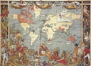
It's a real Ripping Yarns-type map, with gathered natives and animals from our conquered/discovered lands standing around the edges, looking remarkably happy with their lots. The imperial territories are marked in red: the British Isles (including Ireland), the Falklands, Canada, India, Southern Africa, Australia, New Zealand…
After studying the map for several minutes, an interesting thought occurred to me: how jolly clever of us only to conquer countries that speak English!
....and they did it all in the name of God!!!
Well I'll be damned! The world isn't pink any more. and worse I haven't got her a card. Being an optimist though I reckon that the cadburies cream egg will do the trick. We can't wait to see the chocolate turn into a map of Britain. We've wanted one ever since we've seen it on the advert during coronation street